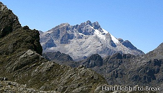
The largest mountain range in South America, The Andes, It also has a presence in Venezuelan territory, specifically in almost 3,000 kilometers of the coasts, which makes a truly spectacular landscape by combining the mountains with the Caribbean waters. Its highest part is in the Bolívar peak, at 5,007 meters of altitude and which is also the highest peak in the entire country.
The Venezuelan Andes They are obviously the most important reliefs in the country. They are in the west-northwest and share a leading role with the Sierra de Perijá, which are in the west and are also spectacular. The depression of the Lake Maracaibo stands out above the rest of the Andes, with some 52,000 square kilometers and is invaluable, both economically and landscape-wise. This basin is home to more than 70% of Venezuela's oil exploitation.
Since pre-Columbian times, this Andean area has already been chosen by the country's inhabitants to build their homes and start developing their activities. The Venezuelan Andes begin in the Táchira depression and extend in a northwest direction for 300 kilometers to reach the Barquismeto-Acarigua depression. The mountain range culminates in a spectacular tectonic block in the vicinity of Merida and close to other valleys that help form an impressive natural complex.
Upon arriving at BarquisimetoThe chains begin to separate to form different landscapes, with some going northwest and others continuing towards the Caribbean mountain system. The Venezuelan Andes encompass the states of Apure, Barinas, Lara, Mérida, Táchira and Trujillo. They have various mountain ranges, although the most famous are the Sierra Nevada de Mérida and Sierra La Culata, both in the middle of the mountain range and in the state of Mérida.
Driving Through Andes Mountains, Venezuela (April 2024)
- 1,230